


Dataset
Luftbildplan 1992 Wien
| Maintainer | Magistrat Wien - Magistratsabteilung 41 - Stadtvermessung |
|---|---|
| Maintainer Link | https://www.wien.gv.at/kontakte/ma41/index.html |
| Maintainer Email | ogd@ma41.wien.gv.at |
| Publisher | Stadt Wien |
| Publisher Link | https://digitales.wien.gv.at |
| Publisher Email | open@post.wien.gv.at |
| License | Creative Commons Namensnennung 4.0 International (CC BY 4.0) |
| License Citation |
Datenquelle: Stadt Wien - https://data.wien.gv.at |
| Terms URL | https://data.wien.gv.at/nutzungsbedingungen |
| Metadata Link | https://www.wien.gv.at/stadtentwicklung/stadtvermessung/service/luftarchiv.html https://www.data.gv.at/infos/geowebservices-potenzial-besser-nutzen/ |
| Geographic Toponym | Wien |
| Geographic Bounding Box | WGS84: POLYGON ((16.577511 48.322571, 16.18218 48.117668)) |
| Beginning Date/Time | May 24, 1992, 02:00 (+0200) |
| End Date/Time | May 25, 1992, 02:00 (+0200) |
| Update Frequency | nicht geplant |
| Lineage Quality | Luftbildbefliegung 25.05.1992; Auflösung 50 cm; Gescannte Schwarz-Weiß Film-Negative Maßstab 10000; |
| Schema Name | OGD Austria Metadata 2.6 |
| Schema Language | ger |
| Schema Characterset | utf8 |
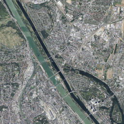
| Resource title and description in English | Aerial Image Catalogue 1992 Vienna The aerial image catalogue from the year 1992 covers the entire city area of Vienna with a pixel size of 50 centimetres. The aerial images were taken on the 25th of May 1992. |
| ID | cef007c8-5836-47a4-b45a-60eb587db17e |
| Human readable URL | https://www.data.gv.at/katalog/en/dataset/luftbildplan-1992-wien |
-
Details
Field Value Metadata last updated February 11, 2025 Data Format HTML License Creative Commons Namensnennung 4.0 International (CC BY 4.0) Data Identifier 41775fa7-9bf1-448d-ad46-146659bc0b80 Metadata Identifier cef007c8-5836-47a4-b45a-60eb587db17e Data URL https://www.wien.gv.at/stadtentwicklung/stadtvermessung/index.html -
Details
Field Value Metadata last updated February 11, 2025 Data Format JPEG Data Size 6.7 MiB License Creative Commons Namensnennung 4.0 International (CC BY 4.0) Data Identifier c9f4a792-3620-4d88-b96f-115c84c60458 Metadata Identifier cef007c8-5836-47a4-b45a-60eb587db17e Data URL https://www.wien.gv.at/ma41datenviewer/downloads/geodaten/lb_img/35_4_lb1992.zip -
Details
Field Value Metadata last updated February 11, 2025 Data Format JPEG License Creative Commons Namensnennung 4.0 International (CC BY 4.0) Data Identifier 0571de29-e3fa-4caf-bde4-83f276168202 Metadata Identifier cef007c8-5836-47a4-b45a-60eb587db17e Data URL https://mapsneu.wien.gv.at/wmts/lb/farbe/google3857/12/1419/2234.jpeg -
Details
Field Value Metadata last updated February 11, 2025 Data Format wmst License Creative Commons Namensnennung 4.0 International (CC BY 4.0) Data Identifier 78074131-dafb-4a18-b081-3ce536eedb76 Metadata Identifier cef007c8-5836-47a4-b45a-60eb587db17e Data URL https://mapsneu.wien.gv.at/wmtsneu/1.0.0/WMTSCapabilities.xml